Intersection of 13, 30 still an ideal location
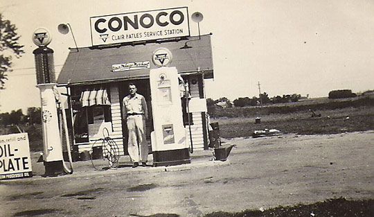
IDEAL LOCATION — At the business corner of 415 Southeast Second Street, New Richland, this mid-1930s building was the first, and this man was the second proprietor of the service station at the intersection of Highways 13 and 30, longtime home to One Stop and future home of Casey’s.
By RODNEY HATLE, NRAHS
Contributing Writer
(Part One of two parts.)
At this corner, New Richland’s very own, locally-owned One Stop eventually became the town’s one-and-only clerk-on-site gas station, and a convenience store.
The property has been sold and a new corporate building with similar service is forthcoming.
History shows that New Richland has had about a dozen small gas stations over the years – as many as eight at the same time. That was not so different from other towns of its size since 1930.
In 1940, the date written on this picture, this corner was nearing its 10th year as one of New Richland’s “filling stations.” It had been the second, but by 1940 there were several more. Four others were on this road, Highway 30. Four were on Broadway Avenue, two of which were across from each other on what is now First Street South, and two were across from each other at Third Street North.
The business site immediately south of the Conoco in this picture does date to 1930. It was originated by A.A. (Albert) Sybilrud who sold to Reginald and Louise Sauer in 1931, according to Reg jr., now of New York state. It was Pure Oil. The family sold to Anthony and Iona Arnfelt in 1955.
This intersection of Highways 13 and 30 was an ideal location for the newest American enterprise, the filling station. Automobiles were selling well and wheeling along well enough, considering the dry hard-packed dirt roads that were being very gradually graveled.
The horse and buggy and the automobile had been in competition since the early twentieth century. For at least two decades both were thoroughly viable according to their various abilities.
When roads were mud, the horse was best with wagon or carriage. When roads were plugged with snow, the horse was also best with sled or sleigh. When the metal mechanism vehicle on wheels and its engine horsepower improved, the automobile was better.
When roads were improved, the automobile was even better. The “horseless carriage” had arrived as year-round viable and affordable transportation.
Larger communities on main highways had gas stations earlier than 1930, of course. As vehicle improvements were being made, junctions such as this at numbers 13 and 30 highways were recognized as ideal for business.
The complete story is one of multiples endlessly tied to the ups and downs that drive an economy.
The developments of better metals, tires, and fuels enabled cars and trucks to grow in size and power. They needed the fuel of gasoline, and they needed it to be out on the roads.
Highway 13, “so designated by the state in 1920,” originally skirted New Richland going north one mile from this junction, according to local observers. It then turned west for two miles before turning north again to Waseca.
After changes in the 1930s which routed the road straight north as it is today, the former No. 13 was called Old 13, passing Otisco on the west side and entering Waseca that way.
To enhance the background about this 13/30 intersection it should be noted that state Highway 30 was authorized in 1933. (“Minnesota State Highway History, 2011 and 2017”) Entering from the west, it turned south at this intersection so that for one mile 13 and 30 overlapped. Then Highway 30 headed east and was a country gaveled road entering Steele County.
What seems to have always been the most natural thing was to take place shortly into the 1950s. The road toward St. Olaf Lake was paved and re-assigned as Highway 30, and an addition to it was built up for the two long curves that now traverse very low-level farmland to the Steele and Waseca county line.
For further historical connection with these gas stations, it should also be noted that dirt hard-pack roads which became designated highways were eventually graveled, and then very eventually paved. Factors which brought this to be were money and necessity, the latter having to do with speed and safety. And that didn’t happen all at once, either.
“Highway 13 was ... completely paved by 1940,” according to Minnesota state history. “Highway 30 was paved in its entirety by 1963.”
New Richland is within the south one-fourth of Highway 13’s total 112 miles from Albert Lea to West St. Paul. And New Richland is in the east one-fourth of Highway 30’s total 266 miles from the South Dakota state line to Rushford. (“Minnesota State Highway History”)
Currently, this intersection is undergoing another change with a new business to be built on the acres purchased by Casey’s General Store, Inc. The 415 Southeast Second Street property now includes the residential lot and house immediately to the west.
(To be continued.)